
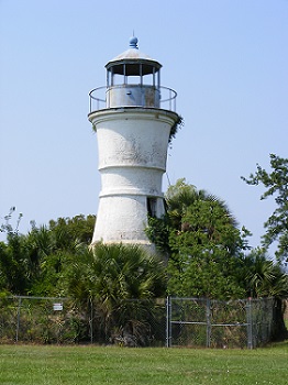
Milneburg/Pontchartrain Beach/Port Pontchartrain Light
ARLHS USA-650
ARLHS World List of Lights (WLOL)
Located in United States Of America Call Area
|
| ARLHS USA-650 PORT PONTCHARTRAIN, LA Copyright 2011 KD3CQ |
|
| ||||||||||||||||||||
This record modified April 06, 2017. - Feedback to the WLOL Maintainer
| Amateur radio activity for this Lighthouse | |||
|---|---|---|---|
| Start Date | End Date | Callsign | Notes |
| 2023-11-28 | 2023-11-28 | K2KJD | Last activation 9 years ago. Expect to operate on 14.270, 7.270, 10 m and if there’s enough time 40 and 20 m CW. Will spot frequencies |
| 2011-06-14 | 2011-06-14 | KD3CQ/ | |
The information contained within the ARLHS World List of Lights is Copyright 2003-2024 ARLHS, LLC.
Visit ARLHS for usage information.
Database HTML Rendering Programs, MySQL Schema and Web Site Content (excluding the actual lighthouse data)
Copyright 2006-2024 John Huggins
PHP/MySQL Database Engine: $Revision: 1.90 $
Lighthouse Display Program: $Revision: 1.50 $


