ARLHS

Narraguagus Light

ARLHS USA-526

ARLHS

ARLHS World List of Lights (WLOL)


Located in United States Of America Call Area

Narraguagus Light pre 1875 - Public Domain 1870 USCG
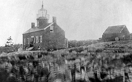
Narraguagus Light pre 1875
Public Domain 1870 USCG

Add a photograph

Details
Also Known As:
ARLHS USA 526, USA-526, USA 526, Narraguagus, ME
State or Province Maine
Lighthouse Coordinates
(DO NOT USE FOR MARINE NAVIGATION)
44.45602, -67.83132
44° 27.361' N, 067° 49.879' W
44° 27' 22" N, 067° 49' 53" W
Map Link - KML
Maidenhead Coordinates
aka 'Gridsquare'
FN64ck
Structure removed, relocated, destroyed or otherwise lost? no
Listed in the World List of Lights since
2006-06-01
Since 1934, The light's function is fulfilled by a bell buoy offshore (USCG 1-1635).

http://www.lighthousefriends.com/light.asp?ID=767

http://www.unc.edu/~rowlett/lighthouse/me.htm
Google Map in New Window
Red Lighthouse Map Icon
Approx. Location
yellow Lighthouse Map Icon
Location Report Received
Green Lighthouse Map Icon
Location Verified

Circle shows 1000m radius from light

This record modified April 26, 2014. - Feedback to the WLOL Maintainer

Amateur radio activity for this Lighthouse
Start DateEnd DateCallsignNotes
2019-07-122019-07-13VE3CBK/W1/QRPAlso activated USA-527 and USA-597
Add a past, current or future operation.
Activation Start Date - YYYY-MM-DD
Activation End Date - YYYY-MM-DD
(only if multiple days)
Callsign of activator
Notes

The information contained within the ARLHS World List of Lights is Copyright 2003-2024 ARLHS, LLC.
Visit ARLHS for usage information.

Database HTML Rendering Programs, MySQL Schema and Web Site Content (excluding the actual lighthouse data)
Copyright 2006-2024 John Huggins
PHP/MySQL Database Engine: $Revision: 1.90 $
Lighthouse Display Program: $Revision: 1.50 $