
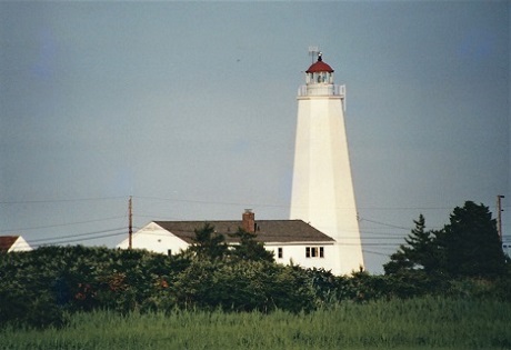
Lynde Point/Saybrook Inner Light
ARLHS USA-462
ARLHS World List of Lights (WLOL)
Located in United States Of America Call Area
|
| Lynde Point Lighthouse Copyright 2001 KF4ZLO |
|
| ||||||||||||||||||
This record modified April 06, 2017 - Feedback to the WLOL Maintainer
| Amateur radio activity for this Lighthouse | |||
|---|---|---|---|
| Start Date | End Date | Callsign | Notes |
| 2019-10-13 | 2019-10-13 | KD3CQ/ | I-95S, Exit 69 to CT154, R on CT-154 MAIN St., cross water & take L on NIBANG Ave (Sequassen Ave) & go R (semi-private warnings,etc.,) I followed around golf course & could see USA-740 and then USA-462; parked off road & no one bother us (but they have the right to tell us to move!) Dan KD3CQ |
| 2005-04-03 | 2005-04-03 | WB1BVQ | |
| 2003-04-19 | 2003-04-19 | WB1BVQ | |
The information contained within the ARLHS World List of Lights is Copyright 2003-2026 ARLHS, LLC.
Visit ARLHS for usage information.
Database HTML Rendering Programs, MySQL Schema and Web Site Content (excluding the actual lighthouse data)
Copyright 2006-2026 John Huggins
PHP/MySQL Database Engine: $Revision: 1.91 $
Lighthouse Display Program: $Revision: 1.50 $


