
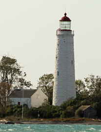
Chantry Island (Lake Huron) Light
ARLHS CAN-619
ARLHS World List of Lights (WLOL)
Located in Canada Call Area
|
| Chantry Island Lightstation Tower Copyright 2015 TA Heart |
|
| ||||||||||||||||||
This record modified March 24, 2017 - Feedback to the WLOL Maintainer
| Amateur radio activity for this Lighthouse | |||
|---|---|---|---|
| Start Date | End Date | Callsign | Notes |
| 2026-03-12 | 2026-03-12 | VE3WLX | |
| 2026-03-10 | 2026-03-10 | VE3WLX | |
| 2025-06-23 | 2025-06-23 | VE3WLX | |
| 2023-08-24 | 2023-08-24 | VE3WLX | 13:00 GMT plus or minus Cancelled if lake is to rough our boat has issues. This is an Island activation. Very first island on air for me. SSB 20m,17m,15m |
| 2019-10-22 | 2019-10-22 | VE3ISE | 2 HOUR ACTIVATION |
| 2005-12-30 | 2005-12-30 | VE3TPZ | |
The information contained within the ARLHS World List of Lights is Copyright 2003-2026 ARLHS, LLC.
Visit ARLHS for usage information.
Database HTML Rendering Programs, MySQL Schema and Web Site Content (excluding the actual lighthouse data)
Copyright 2006-2026 John Huggins
PHP/MySQL Database Engine: $Revision: 1.91 $
Lighthouse Display Program: $Revision: 1.50 $


