
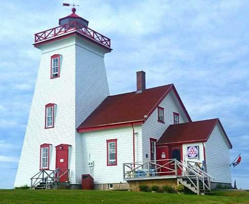
Wood Islands Light
ARLHS CAN-535
ARLHS World List of Lights (WLOL)
Located in Canada Call Area
|
| Wood Islands Copyright 2024 |
|
| ||||||||||||||||||
This record modified April 24, 2024 - Feedback to the WLOL Maintainer
| Amateur radio activity for this Lighthouse | |||
|---|---|---|---|
| Start Date | End Date | Callsign | Notes |
| 2023-05-20 | 2023-05-20 | VY2GF | In conjunction with POTA VE-0880 |
| 2022-06-03 | 2022-06-05 | VY2PLH | |
| 2021-08-21 | 2021-08-21 | VY2GF | ILLW |
| 2020-08-22 | 2020-08-23 | VY2PLH | ILLW - CA0051. CAN 536/537 also activated |
| 2020-08-21 | 2020-08-21 | VY2GF | |
| 2020-05-24 | 2020-05-24 | VY2GF | 20m SSB around 14240. 1400UTC - 1800UTC |
| 2018-05-18 | 2018-05-20 | VY2PLH | 2000UTC/18 until 1800UTC/20. SSB and digital. CAN 536/537 also activated. |
| 2016-08-20 | 2016-08-21 | VY2PLH | CAN 536 & CAN 537 will also be activated. Permanent antenna installed - G5RV Junior |
| 2015-10-16 | 2015-10-18 | VY2PLH | CAN 536 and CAN 537 will also be activated |
The information contained within the ARLHS World List of Lights is Copyright 2003-2026 ARLHS, LLC.
Visit ARLHS for usage information.
Database HTML Rendering Programs, MySQL Schema and Web Site Content (excluding the actual lighthouse data)
Copyright 2006-2026 John Huggins
PHP/MySQL Database Engine: $Revision: 1.91 $
Lighthouse Display Program: $Revision: 1.50 $


